NEARSHORE CABLE LAYING OPERATIONS (#70)
OFFSHORE WIND MARINER UPDATE NO. 70
STATUS: Complete
On or about the 11th of January 2023 in preparation for Cable Laying Operations there will be a construction barge and a materials barge along with tugs KODIAK and BUCKY performing Diving Operations at the HDD Cable ducts to get the cables ready for connection and pull-in to the beach. Additionally, six smaller workboats and a Crew Transfer Vessel will assist in these operations. Subsequently, the Cable Barge ULISSE will be towed to site by the NICOLE FOSS and begin conducting cable laying operations approximately 700m (0.4nm) off Covell’s Beach, Barnstable. The cable will be pulled to shore by an onshore winch, once secured the ULISSE will lay and bury the cable away from the beach out to the Cape Poge area. Attending the ULISSE cable laying operations will be the support vessels MENA C & MARTINE P that will be performing anchor handling for the operations. F/V HELEN H will be operating around the activities as a safety vessel to monitor traffic and facilitate the safe movement of fishing vessels, recreational craft, or other transiting vessels, around the work sites and project vessels. F/V TENACIOUS II will be the safety vessel and F/V PROVIDER will be the guard vessel for nearshore operations off of Covell’s Beach.
PLEASE NOTE: All Mariners transiting or fishing in the area are requested to give a wide berth to the vessels as they are limited in their ability to maneuver, and the Cable layer ULISSE will have gear out 1500m ahead of the vessel and up to 1500 meters behind the vessel. The ULISSE will operate on a 5-point mooring spread utilizing the full width of the Offshore Export Cable Corridor (OECC). The mooring spread will consist of four positioning anchors positioned up to 1 km or 0.54 nm from the barge and a single pulling anchor positioned up to 1.5 km or 0.82 nm. Her anchors will be deployed with pennant buoys and will be marshalled by various support vessels. Vessels in the vicinity of the operations are requested to operate in a manner as to not endanger the vessel or associated equipment. Passing arrangement can be made via VHF with the vessels.

LOCATION(S): Beginning just offshore of Covell’s Beach and continuing along the cable corridor across Nantucket Sound down to the Cape Poge area.
All vessels will be standing by on VHF channel 13 & 16
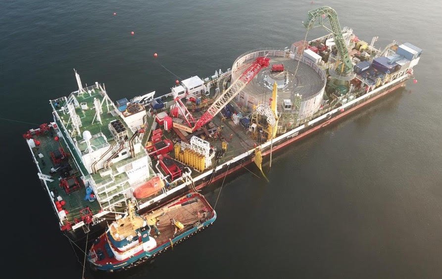
CLB ULISSE
CLB ULISSE
Flag: Malta
Length: 400’
MMSI#: 249651000

NICOLE FOSS
NICOLE FOSS
Flag: USA
Length: 130’
MMSI#: 367774490

MENA C
MENA C
Flag: United Kingdom [GB]
Length: 87’
MMSI#: 235090339

MARTINE P
MARTINE P
Flag: United Kingdom [GB]
Length: 87’
MMSI#: 235091541

KODIAK
KODIAK
Flag: USA
Length: 62’
MMSI#: 367763260

BUCKY
BUCKY
Flag: USA
Length: 54’
MMSI#: 367112070
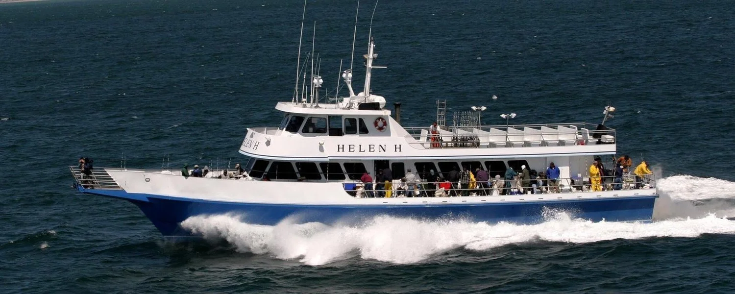

HELEN H
Flag: USA
Length: 85’
MMSI#: 367554870
Captains: Dylan Phaneuf / Tyler Huckermeyerz
Phone: 508-498-5535 / 774-994-1146
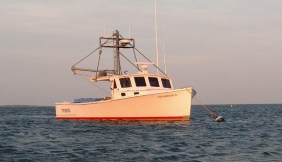
TENACIOUS II
Flag: USA
Length: 40’
MMSI#: 367400280
Captain: Eric Hesse
Phone: 508-364-1100
PROVIDER
Flag: USA
Length: 75’
MMSI#: 367717050
Captain: Scott Dernberger
Phone: 401-626-7622
VINEYARD WIND
Michael Clayton, Project Manager, Cell: 484-868-3747 • Email: mclayton@vineyardwind.com
Jen Cullen, Fisheries Liaison, Cell: 508-648-4184 • Email: jcullen@vineyardwind.com

VineyardWind.com • info@vineyardwind.com • 508-717-8964
O&M Building on MV 69 Beach Rd. Vineyard Haven, MA 02568